Abbey of San Pietro al Monte, from the car park on Via Valle dell'Oro

Edited by:
Massimo Martini
Updated at: 08/09/2026
Access
Road directions
Take the Civate exit towards Civate/Oggiono/Bellagio (36.6 km from the junction with the Milan North Ring Road). At the exit, continue straight on for 750 metres, then take the second exit at the roundabout. Turn right onto Via Provinciale and go straight on at the next roundabout. At the following roundabout, take the third exit to join the (36.6 km + 640 m = approx. 37.2 km). Continue along Via Papa Giovanni XXIII for 260 m (37.5 km); at the roundabout, take the second exit onto Via S. Paolo for 250 m (37.7 km), then continue along Via Bellingera for 140 m (37.9 km), then turn right onto Via Baselone. After 260m, turn left to stay on Via Baselone (38.4km); the road curves slightly to the left and becomes Via Valle dell’Oro. The car park is on the left after 600m (39.0km in total).
Car park
On Via Valle dell’Oro, there is a free 🅿️ car park on a dirt track right next to the start of Trail 10. On public holidays and during busy periods, spaces may be fully occupied; alternatively, the car park 🅿️ on Via Baselone and the signposted municipal car parks in the centre of Civate are available.
Access by public transport
The site can be reached from Milan via the S7 line (Monza–Molteno–Lecco), alighting at Civate. From Lecco and Como, take bus route C40, alighting at Civate – Paese – Municipio. From the centre of Civate, the car park on Via Valle dell’Oro is just a few minutes’ walk away. Distance and journey time
🕒 journey time: 34 minutes
📏 distance: 39.6 km
GPS navigation
Important information
The directions provided were verified on the date the route was mapped. Before setting off, we recommend checking for any changes to the route or road conditions. For up-to-date information, please consult Google Maps or Apple Maps.
Introduction
A round-trip route that follows the Valle dell’Oro up the slopes of Monte Cornizzolo, reaching the Romanesque monastic complex of San Pietro al Monte at an altitude of 630 metres via a historic mule track dating back to the Lombard period. The route follows path in its entirety, with a moderate elevation gain and a well-signposted route, suitable for walkers of all levels of experience, including families. The route passes through a chestnut woodland, passes a series of ‘casote’ — dry-stone shelters typical of the Cornizzolo area, a reminder of a high-altitude farming tradition that has now disappeared — and ends on a wide grassy plateau where the Benedictine complex stands out against the mountain’s cliffs. The difficulty is moderate in the initial section, becoming steeper in the final stretch where the mule track narrows and climbs via regular steps. The view that opens up from the abbey’s plateau takes in Lake Annone, Mount Barro and Mount Resegone: a sweeping and unexpected vista for such a short route.
Description
[0h00’T2] 0.00km From the car park 🅿️ on Via Valle dell’Oro, follow the signs for the Basilica of San Pietro al Monte. Walk briefly alongside the Rio Toscio and enter the woods along a narrow dirt track which, after a few minutes, gives way to a cobbled mule track. The route remains flat as it runs alongside the small hamlet of Oro to the wayside shrine at Faello (404m), where a spring 💧 also marks the location of the information boards for theAnello delle Casote di Civate trail.
[0h15’T2] 0.31 km (48 m ascent) (2 m descent) At a house, turn right, following the signposts for path . Once past the newsagent’s, a few stone steps lead to a short ford across the Rio Toscio; from here, the mule track resumes, climbing gently up the valley until it reaches a junction marked by a signpost.
[0h30’T2] 0.78km Turn left, staying on the cobbled mule track. A little further on, you come to casota no. 2 (475m), a circular dry-stone structure typical of the pre-Alpine rural architecture of the Cornizzolo: used as a night-time shelter during haymaking, an emergency shelterand a store for agricultural tools; it is built with blocks of limestone stacked in concentric rings — a technique that bears witness to nineteenth-century high-altitude farming culture.
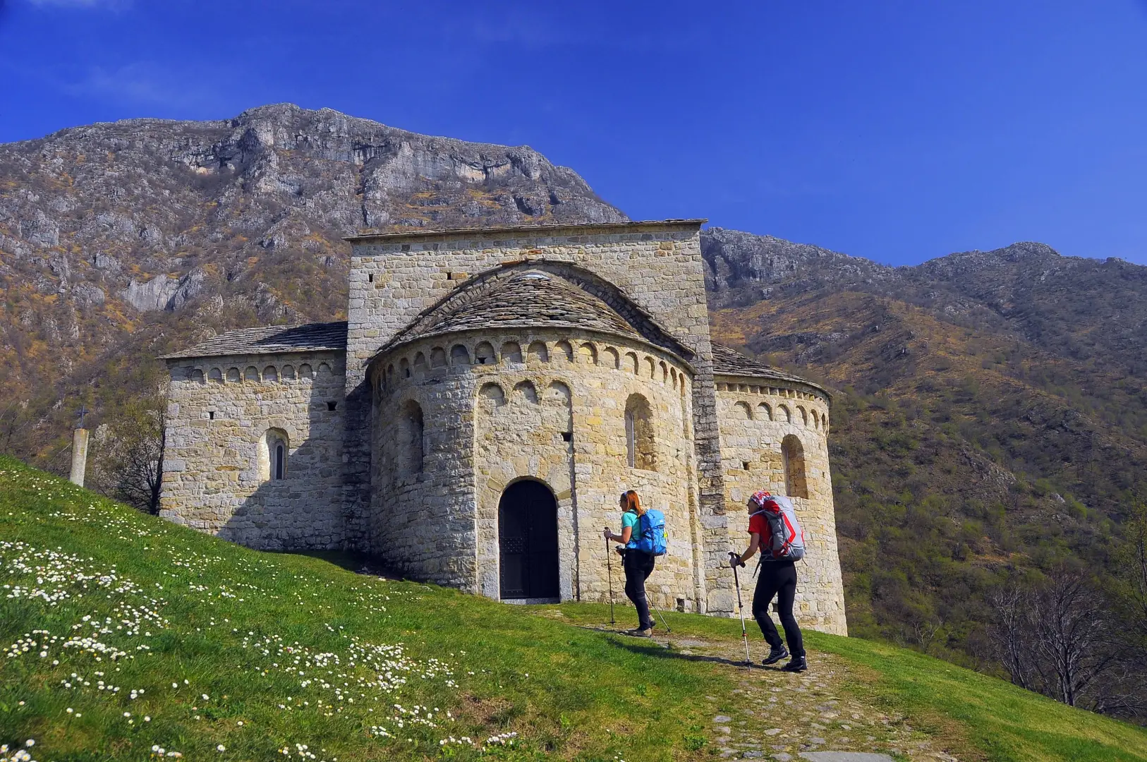
[0h45’T2] 1.07km The mule track gains altitude again via wide steps that wind through the beech forest along a series of short bends. Along the route, you’ll come across wooden sculptures depicting forest animals. As you approach the plateau, the woodland opens out onto the meadows below the monastic complex. A sign from the Gruppo Giovane Montagna marks the point just before the right-hand bend that brings the Basilica of San Pietro al Monte into view; it can be reached via a short stretch along the hillside. At the entrance to the enclosure stands the Oratory of San Benedetto, adjacent to the Basilica. From the plateau, the view opens out onto a section of Lake Annone, Mount Barro and Mount Resegone, leading to the complex of the Basilica of San Pietro al Monte (689m) [1h15’T2] 1.53 km (346 m ascent) (15 m descent).
The return journey follows the paved mule track in the opposite direction back to the car park at the start [0h45’T2] 1.53 km .
Visitor information
Visits inside the Basilica of San Pietro al Monte are possible every day except Mondays, with free entry on Saturdays and Sundays; on other days, booking is required through the Associazione Amici di San Pietro al Monte. The outdoor area is freely accessible and offers ample space for picnics.
Places of Interest
Abbey of San Pietro al Monte
Oratory of San Benedetto
Civate
Comments (0)
Sign in to leave a comment